
Your Guide to Walkable City of Jenks Design
- Jul 12, 2025
- 16 min read
Updated: Jul 13, 2025
Walkable City of Jenks design is really just a way of planning and building places where you can get what you need with a short, safe, and even pleasant walk. It's a conscious choice to put people ahead of cars, weaving together mixed-use zoning, smart street connectivity, and infrastructure that makes walking the easiest, most logical option. When done right, this philosophy cultivates communities that are healthier, more prosperous, and built to last.
Laying the Groundwork for a Walkable Community
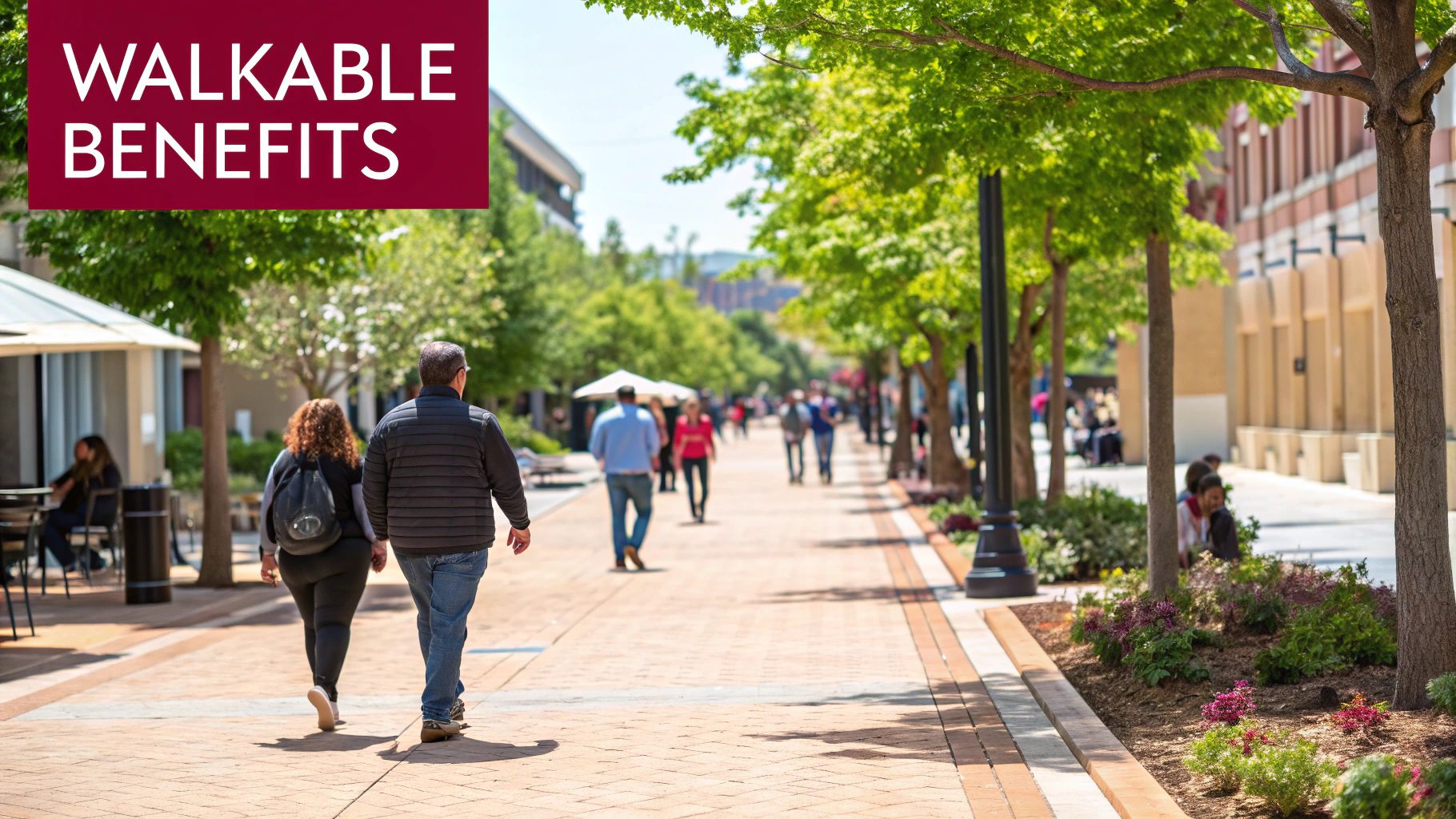
Creating a truly walkable city is about much more than just pouring sidewalks. It requires a fundamental shift in how we think about and build our communities. Instead of designing everything around the needs of a car, this human-scaled approach places the pedestrian experience at the very heart of every decision.
The end goal is to shape places where people feel comfortable, safe, and genuinely engaged as they move through their day on foot. This isn’t just a fuzzy ideal; it’s built on a few core principles that work together to create a vibrant urban fabric. These are the practical, foundational elements we’re implementing to bring that vision to life here in The Ten District.
The table below outlines the core pillars that are essential for any successful walkable city initiative. These components are interconnected, each one reinforcing the others to create an environment where walking is not just possible, but preferred.
The Core Pillars of Walkable City Design
Pillar | Key Objective | Example Implementation |
|---|---|---|
Mixed-Use & Density | Create vibrant, 24/7 neighborhoods where daily needs are within walking distance. | Combining apartments above ground-floor retail and restaurants on the same block. |
Connected Grid | Make walking direct, efficient, and intuitive by providing multiple route options. | Designing a network of shorter blocks with frequent, safe intersections. |
Human-Scale Design | Ensure buildings and public spaces feel welcoming and comfortable to pedestrians. | Limiting building heights, requiring active storefronts, and adding street trees. |
Pedestrian Infrastructure | Prioritize the safety, comfort, and accessibility of people on foot. | Installing wide, continuous sidewalks, high-visibility crosswalks, and public seating. |
By focusing on these four pillars, we can create a district that is not only easy to navigate on foot but also a destination in its own right—a place where people want to spend their time and money.
The Power of Mixed-Use and Density
One of the most critical elements is embracing mixed-use development. Think about it: when homes, shops, offices, cafes, and parks all share the same neighborhood, the need to jump in a car for every little errand starts to fade away.
This intentional mix of uses breathes life into a district around the clock. Residential streets don't turn into ghost towns during the workday, and commercial areas don't die after 5 PM. It creates a dynamic, bustling environment where active streets naturally lead to better safety and a stronger sense of community. The numerous benefits of mixed-use development are absolutely essential for building a local economy that thrives on foot traffic.
A well-executed mixed-use strategy doesn't just add convenience; it builds a self-sustaining local ecosystem. Increased foot traffic from residents supports local businesses, which in turn provide essential amenities and job opportunities, strengthening the entire community from the ground up.
Creating a Connected and Permeable Grid
Just as important is the layout of the street network itself. A truly walkable design steers clear of the sprawling, disconnected patterns common in many suburbs—think long, winding blocks and dead-end cul-de-sacs that force you into ridiculously long and indirect routes. Instead, it relies on a highly connected grid.
This kind of network has a few key features:
Shorter block lengths: This creates more intersections and gives people more direct paths, making a walk feel more efficient and interesting.
High street connectivity: The grid ensures there are many ways to get from Point A to Point B, which helps disperse foot traffic and encourages people to explore.
Prioritized pedestrian routes: The design makes sure sidewalks are direct, continuous, and clear of obstacles, truly making walking the path of least resistance.
A grid is simply more intuitive. It can turn a simple walk from a chore into a chance for discovery, with every corner offering a new path or potential destination. When a neighborhood is this easy to navigate on foot, people are far more likely to leave their cars parked for short trips, which means less traffic, cleaner air, and a more vibrant community. This interconnectedness is the skeleton that a thriving, walkable district is built on.
Building Consensus Through Community Engagement
Let's be honest: a perfectly designed walkable district is just lines on a map until the community gets behind it. You can have the most brilliant plans for walkable city design, but they'll fail if they don't serve the people who actually live, work, and spend their time there. Gaining that trust and support means moving far beyond the classic, and often useless, town hall meeting where only the loudest voices get heard.
Real consensus doesn't happen by accident. It's built by deliberately and actively seeking out every stakeholder—residents, local shop owners, and even frequent visitors. It’s about making them feel like true partners in the process, not just spectators watching from the sidelines.
Ditch the Old Public Meeting Model
The old way of doing things is broken. Presenting a nearly-finished plan and asking for "feedback" doesn't build trust; it breeds resentment and leaves people feeling like their input is just a box to be checked. A much better way is to bring the community in from the very beginning, when the ideas are still taking shape and their input can make a real difference.
This means you need a more dynamic and accessible toolkit for engagement. Instead of one formal meeting, think about a mix of approaches that meet people where they are.
Pop-Up Planning Booths: Ever tried setting up a table at the local farmers' market or a community festival? Grab some large maps, sticky notes, and ask simple questions. "What would make this street better for walking?" or "Where do you feel unsafe crossing?" You'll get incredible, on-the-ground feedback.
Walk-and-Talk Workshops: Get people out of their chairs and into the environment you're discussing. Host guided walking tours of the proposed area. It’s amazing how the conversation changes when people can point to a specific cracked sidewalk or a dangerous intersection in real-time.
Design Charrettes: These are my personal favorite. They're intense, hands-on workshops where community members, planners, and designers literally roll up their sleeves and sketch out ideas together over a few days. This creates a powerful sense of shared ownership that you just can't get any other way.
Navigating Conflict and Finding Common Ground
One of the biggest friction points you'll encounter is the perceived battle between pedestrian-friendly streets and vehicle access—specifically, parking. I've seen it time and time again. Local business owners voice very real concerns that removing on-street parking will kill their business.
You have to approach this with empathy, hard data, and a bit of creative problem-solving.
It’s a common myth that more parking automatically equals more business. The data often tells a different story. While a driver might spend more in a single trip, pedestrians and cyclists tend to visit more often, ultimately spending more money over the course of a month. The key is to shift the conversation from "parking" to "access."
Instead of framing it as cars vs. people, focus on making the district more accessible for everyone. Here are a few things that have worked in other communities:
Run customer origin surveys: Team up with local businesses to ask customers how they got there. You'll often be surprised to find that a huge chunk of their patrons already walk, bike, or use transit. That data is gold.
Show them the money: Share case studies from similar districts. When other towns have made pedestrian-focused improvements, they’ve often seen a 10-30% jump in retail sales. Money talks.
Propose creative solutions: Maybe the answer isn't fighting over a handful of spots on Main Street. Explore building a shared parking garage on the edge of the district, improving signs to existing lots, or creating designated drop-off zones for Uber and Lyft.
If you're looking to really shake things up, exploring some fresh community engagement ideas can help you gather more authentic feedback. The goal is to show people you're listening and proactively addressing their worries. That’s how you turn potential opponents into your biggest champions.
Ultimately, a successful walkable district in The Ten District will be one that reflects the unique identity and collective vision of the entire community.
Designing a Connected and Cohesive Street Network
The street network is the skeleton of any successful walkable district. While cool amenities and placemaking bring the personality, it's the underlying structure of the streets that truly dictates how people move and whether walking feels like the most natural choice. A well-designed network puts pedestrian flow and safety first, turning a simple walk from A to B into a genuinely enjoyable experience.
Think of it this way: a disconnected, car-centric street system is like a fortress, designed to keep people in their vehicles and funnel them through as fast as possible. In contrast, the principles of walkable city design create a welcoming, permeable grid that practically begs for exploration and connection. This isn't just about making things look nice; it's about engineering a system that works better for everyone.
This visual breakdown shows how all the pieces fit together—from connected sidewalks to mixed-use buildings—to form the backbone of a truly walkable environment.
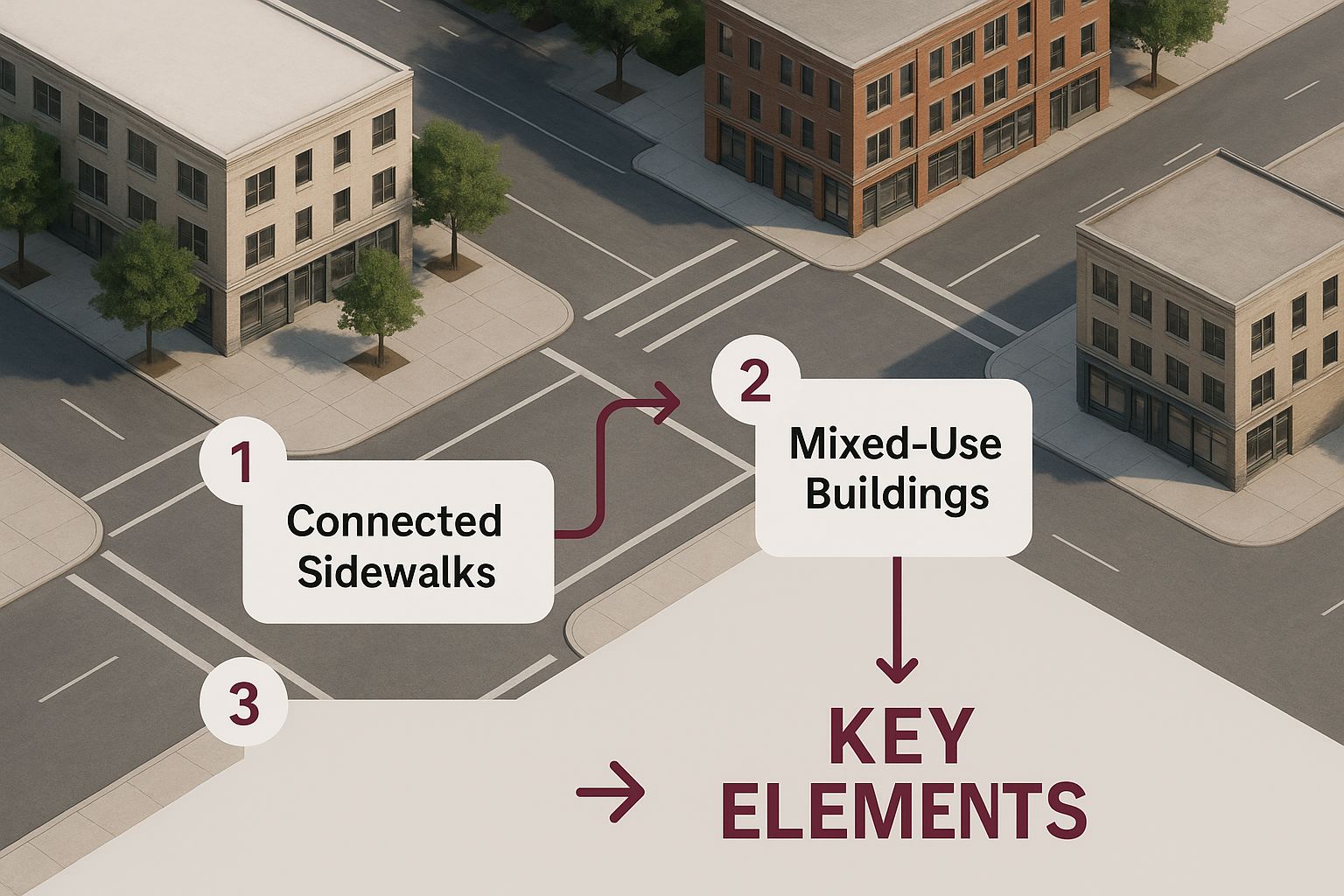
As you can see, it's the interplay between block length, intersection safety, and building placement that makes a street network function for people on foot. It’s a complete system where every part reinforces the others.
Shorter Blocks and More Connections
One of the most impactful changes the City of Jenks can make is ditching the long, sprawling superblocks of the past. Shorter blocks, ideally between 200 and 400 feet, fundamentally change the pedestrian experience for the better.
More intersections mean more route choices, making walking feel more direct, intuitive, and interesting. When you have multiple ways to get somewhere, a five-minute walk isn't a chore; it becomes a chance for discovery. You might take a different path and stumble upon a new coffee shop or a hidden pocket park. This high level of connectivity is what makes a neighborhood feel easy to navigate.
To see this principle in action, you can explore the vision laid out in the Jenks Downtown Master Plan, which makes creating a more connected urban fabric a top priority.
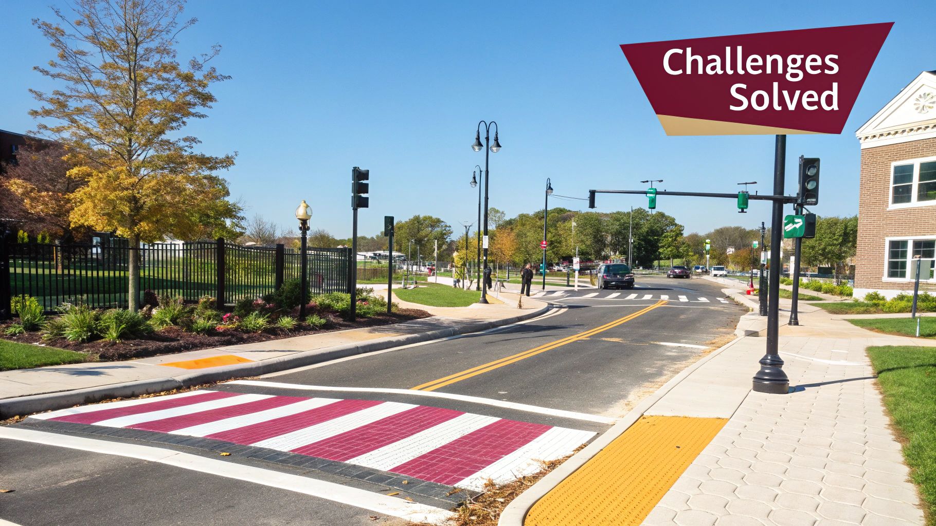
"Complete Streets" and Smarter Traffic Flow
The "Complete Streets" philosophy is simple: our streets should be designed and operated for all users, not just drivers. This means safely accommodating pedestrians, cyclists, and transit riders of all ages and abilities. It’s a conscious shift away from designing roads purely for vehicle speed.
To make this happen, we lean heavily on traffic calming measures. These are physical design features that naturally slow down cars, creating a much safer environment for everyone else.
Some of the most effective tools we use include:
Raised Crosswalks: By elevating the crosswalk to sidewalk level, pedestrians are more visible and drivers are forced to slow down. They act as a subtle but effective speed bump.
Curb Extensions (Bulb-Outs): These extend the sidewalk into the parking lane at intersections. This shortens the crossing distance for people on foot and makes them much easier for turning vehicles to see.
Protected Bike Lanes: Physically separating cyclists from cars with barriers like planters or curbs dramatically improves safety and encourages more people to get on their bikes.
These aren't just one-off features; they work together as a system to rebalance the street in favor of human-powered movement. The benefits aren't just local—they're global.
A recent study by UCLA and Google, which analyzed travel in over 11,500 cities, found that expanding walking and cycling infrastructure could generate an astonishing $435 billion in annual health benefits and significantly cut global carbon emissions. A key driver for this positive change? Redesigning streets to be safer and more comfortable for pedestrians.
The Art of Placemaking in Public Spaces
A connected street network lays the groundwork, but the real magic of a walkable city design happens when those paths lead to places people actually want to be. Great infrastructure is only half the battle. You have to create destinations that draw people in and make them want to stick around.
This is where placemaking comes in—the very human art of turning simple public spaces into vibrant, magnetic hubs that foster real connection.
Placemaking is what transforms a walk from a task into an experience. It’s the subtle but powerful difference between a sterile concrete plaza people rush through and a lively square where they linger, meet friends, and feel a true sense of belonging. It all comes down to layering in thoughtful, human-centric details that invite us to slow down and stay awhile.
Beyond Benches and Bins
Good placemaking starts with the essentials, but it certainly doesn't end there. Sure, you need comfortable seating and enough trash cans—those are non-negotiable. But creating a space that people remember and return to requires a much more creative touch. The goal isn't just function; it's delight.
Think about the small details that make a huge impact:
Strategic Seating: Let's move beyond the standard park bench. Consider movable chairs and tables that give people a sense of control over their environment. Or maybe integrated seating walls that feel like a natural part of the landscape. Offering seating in both sunny and shady spots is also a must, catering to different preferences throughout the day.
Public Art and Interactive Installations: A striking sculpture or a playful mural can become an instant landmark and a source of community pride. Interactive elements, like ground-level water features or light installations, are fantastic for drawing people in and encouraging playful engagement from all ages.
Embracing Greenery: The power of nature in an urban setting is huge. Pocket parks, street trees, and lush planters do more than just make an area look pretty. They provide critical shade, cool down the pavement, and create a calmer, more restorative atmosphere.
These elements work together to give a space its own personality. They send a clear message: this place was designed with your comfort and enjoyment in mind. For a deeper look at how this kind of forward-thinking urban strategy is taking shape, you can read about the real vision behind The Ten District revitalization and see why these details are so critical to our success.
Activating Spaces Through Programming
Even the most beautiful public square can feel hollow without people. Programming is the secret sauce that brings a space to life, giving people a reason to come back time and time again. It’s the ongoing calendar of events and activities that breathes energy into the built environment.
A great public space is like a stage. The physical design sets the scene, but the programming provides the show—the dynamic, ever-changing human activity that makes it a true destination.
Effective programming is always tailored to the local community. It can completely transform a quiet weekday afternoon or a weekend evening into a can't-miss event. These activities are powerful tools for building social bonds and supporting the local economy by driving consistent foot traffic.
Examples of Successful Space Activation
Program Type | Description | Desired Outcome |
|---|---|---|
Farmers' Markets | Regular markets featuring local produce and artisan goods. | Supports local agriculture, creates a weekly community ritual, and drives daytime foot traffic. |
Outdoor Concerts | A series of free, family-friendly musical performances. | Fosters a lively evening atmosphere and showcases local talent, making the district a cultural hub. |
Pop-Up Fitness Classes | Offering activities like yoga or Zumba in a public park or square. | Promotes public health and wellness while utilizing green space in new, active ways. |
Seasonal Festivals | Holiday markets, art fairs, or food truck festivals. | Creates signature, can't-miss events that attract visitors from the wider region and build a strong sense of place. |
These programmed events are what build memories. They create positive associations with a place, making sure the community truly sees these public spaces as their own.
It's this potent combination of thoughtful physical design and dynamic human activity that elevates a simple collection of streets and buildings into a beloved, thriving district. When you get placemaking right, the entire area becomes a destination worth exploring on foot.
Integrating Essential Pedestrian-First Amenities
A connected street grid and vibrant public squares are the bones of a walkable district, but it’s the small details that bring it to life. I’m talking about the micro-amenities that turn a simple walk from point A to point B into a genuinely pleasant experience.
These are the things that make people feel safe, comfortable, and cared for. Without them, even the best walkable city design feels sterile and incomplete. The big-picture planning gets people to a district, but it’s these thoughtful touches that convince them to stay, explore, and come back time and again.
Focusing on Comfort and Convenience
You have to think about basic human needs. They don't just vanish because someone is on foot. When a district anticipates and meets these needs, it sends a powerful message: pedestrians are the priority here. It’s all about removing the little annoyances that can ruin an otherwise great outing.
This starts with something as basic as a place to sit down. And I don't just mean a few token benches. We need frequent and comfortable seating in both sunny and shady spots. This gives people a chance to rest, people-watch, or just take a moment. Movable chairs and tables are even better—they give people a sense of control over their environment.
Accessible public restrooms and drinking fountains are also non-negotiable. If you’re a family with kids or anyone planning to spend a few hours exploring, the lack of these facilities is a dealbreaker.
A walkable district’s success is measured by its "linger-ability." If people feel comfortable enough to rest, refresh, and spend more time without feeling stressed or inconvenienced, you have created a truly human-centric environment.
Ensuring Safety and Navigability
Feeling safe is the absolute foundation of a positive pedestrian experience, especially after dark. Good lighting isn’t just about being able to see; it’s about creating a true sense of security. Human-scale lighting is the key. Think pedestrian-level fixtures, not those towering highway-style lamps. This approach lights up faces and pathways without harsh glare, making the area feel welcoming at all hours.
Beyond lighting, people need to know where they're going. Good wayfinding signage does more than just point to landmarks. It should be intuitive and helpful.
Always include maps with a clear "You Are Here" marker.
Provide estimated walking times (e.g., "5 minutes to the park").
Use a consistent, recognizable design throughout the district.
This kind of clear guidance builds confidence and encourages people to wander off the main drag, knowing they won’t get lost. The goal is to make navigating on foot feel completely natural.
The Foundation: Wide and Unobstructed Sidewalks
Of course, none of these amenities matter if the most fundamental piece of the puzzle is flawed. The sidewalks themselves have to be wide, continuous, and well-maintained. They need to be free from cracks, clutter, and obstacles.
In my experience, the best sidewalks have distinct zones:
Frontage Zone: A buffer area right next to the buildings.
Pedestrian Zone: A clear, unobstructed path that's at least 8-12 feet wide in busy areas.
Furnishing Zone: The space along the curb for street trees, benches, bike racks, and lighting.
This organized approach ensures there’s plenty of room for people to walk side-by-side, pass with a stroller, or use a wheelchair without any issues. That "furnishing zone" is especially critical. It not only holds all the great amenities but also creates a welcome buffer from vehicle traffic.
This whole philosophy ties directly into the "15-minute city" concept, an urban design approach taking hold in cities like Paris and Melbourne. The idea is that residents should be able to get everything they need within a short walk from home. This naturally requires pedestrian-first infrastructure, green spaces, and a cohesive street design. If you're interested in this model, you can explore how cities are reimagining walkability worldwide. It’s these details that truly turn a simple sidewalk into a great public space.
Measuring Success and Planning for the Future
After the concrete is poured, the benches are installed, and the public art is unveiled, how do you know if your walkable district is actually working? The ribbon-cutting ceremony isn't the finish line. In my experience, it's just the starting line for a long game of monitoring, learning, and adapting.
Truly understanding success means looking past simple foot traffic counts. You have to dig into the metrics that really reflect the community's economic, social, and physical health. A great district isn't static; it evolves. The needs of a community change, and a well-designed place must be able to change with them. This means building a framework for long-term stewardship from day one, ensuring your walkable district stays vibrant and responsive for decades.
Defining Your Key Performance Indicators
Before you can measure success, you have to define what it actually looks like for your community. Your Key Performance Indicators (KPIs) should be a practical mix of hard data and real-world feedback. Numbers are powerful, but they don't always tell the whole story.
From what we've seen on the ground, some of the most effective metrics to track are:
Local Business Health: Keep an eye on retail sales data and commercial vacancy rates. Are businesses in the walkable zone seeing more revenue? Are new, desirable businesses moving in? This is a huge indicator.
Resident and Visitor Satisfaction: This doesn't have to be complicated. Simple intercept surveys or QR codes on signage can gather direct feedback. Ask people about their sense of safety, comfort, and whether they're genuinely enjoying the space.
Public Health Indicators: This is a big one. Partner with local health agencies to see if there are changes in physical activity levels or other wellness metrics. A walkable district should make people healthier.
Property Values: An increase in residential and commercial property values within the district is a strong signal of desirability and long-term success.
These KPIs give you a complete picture of your project's impact. If you want to dive deeper into the direct financial upside, you can see how master plans are unlocking economic potential for downtown areas by focusing on these exact measures.
Leveraging Data and Technology
Gathering this data is easier than ever, and you don't need a massive budget to get started. The trick is to be strategic and use the right tools for the job.
Simple pedestrian counters—whether they're basic infrared beams or more advanced camera systems—can provide an invaluable baseline on foot traffic. You can quickly see which areas are most popular and at what times of day. This helps you pinpoint where amenities like extra seating or better lighting might be needed most.
A walkable city is a living system. Data is the language it uses to tell you what's working and what isn't. Listening to that data is essential for making smart, iterative improvements that respond to real-world human behavior.
This data-driven approach allows for constant refinement. For example, if you notice a certain public plaza is underused in the evenings, data might point to poor lighting as the culprit. A simple, targeted upgrade can then be made, and its impact measured. It's a cycle of continuous improvement.
Future-Proofing Your Design
The real goal of walkable city design is to create places that last for generations. This means thinking about future challenges and opportunities from the very beginning. How will the district handle new ways of getting around, like e-bikes and scooters? How can it adapt to shifting retail trends or a changing climate?
A major global trend is the push to increase daily walking. The potential for change is massive. In 2018, the global average walking distance was a mere 200 kilometers per person annually—that’s just seven minutes a day. But a more optimistic projection for 2050, where walkable infrastructure is the norm, models that walkable cities could cover 3.70 trillion passenger kilometers. These scenarios, which you can read about in more detail from Project Drawdown on the global impact of walkable cities, show the incredible mobility shift that thoughtful design can achieve.
Building flexibility into your design is critical. This could mean using modular street furniture that can be rearranged for events or designing "flex zones" on streets that can easily transition from parking to outdoor dining to a pop-up parklet. The key is to avoid rigid, unchangeable designs and instead embrace an adaptable framework.
By combining meaningful metrics, smart technology, and forward-thinking planning, you can ensure that your walkable district doesn't just succeed on opening day, but thrives for generations to come.
At The Ten District, we are committed to building a vibrant, walkable, and enduring community right here in the heart of Jenks. We invite you to be part of our story—explore our shops, enjoy our events, and experience a place designed for people first. Visit us today and see what makes our district so special.
Comments